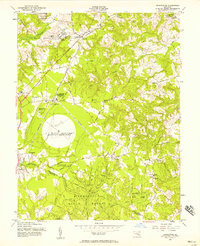
1956 Map of Brandywine
USGS Topo · Published 1958About this map
Boys Village of Maryland and the expansive Cedarville State Forest anchor the rural landscape of southern Maryland during the mid-1950s. This survey reveals a region defined by agricultural crossroads and significant federal installations, including the U S Military Reservation Globecom Radio Receiving Station and a U S Naval Reservation near the headwaters of Piscataway Creek. The Pennsylvania Railroad cuts through the territory, passing near Cheltenham and Brandywine, which serve as local hubs for the surrounding farmsteads.
Find a feature on this map
75 named features on this map. Tap any name to fly to it.
Don’t see what you’re looking for? This feature index may not catch every label — zoom into the map to look around manually.
Map Details
Editions of this 1956 Brandywine Map
4 editions found
Other maps of this area

1892 · Prince Frederick
USGS Topo · 1:62,500

1892 · Brandywine
USGS Topo · 1:62,500

1892 · Owensville
USGS Topo · 1:62,500

1895 · Prince Frederick
USGS Topo · 1:62,500

1895 · Brandywine
USGS Topo · 1:62,500

1895 · Owensville
USGS Topo · 1:62,500

1899 · Patuxent
USGS Topo · 1:125,000

1900 · Washington
USGS Topo · 1:62,500

1901 · Prince Frederick
USGS Topo · 1:62,500

1905 · Owensville
USGS Topo · 1:62,500