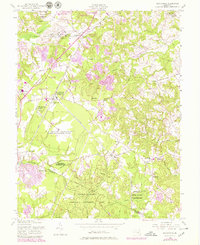
1956 Map of Brandywine
USGS Topo · Published 1979About this map
The Boys Village of Maryland and the sprawling U S Military Reservation Globecom Radio Receiving Station dominate this southern Prince George's County landscape. This 1956 survey, updated with late-1970s revisions, captures a region defined by institutional land use and traditional rural crossroads. Significant military and scientific presence is evident at the U S Naval Reservation and its Magnetic Observatory near Cheltenham. To the south, the Cedarville National Resource Management Area spans the border into Charles County, preserving the headwaters of Zekiah Swamp Run. The map records numerous community centers such as Baden, Horsehead, and North Keys, alongside local landmarks like St Pauls Ch and the Orme Sch. The transition of the local economy is seen in the purple revision overlays, which indicate new residential developments and the tracks of Conrail cutting through the older tobacco-growing countryside.
Find a feature on this map
74 named features on this map. Tap any name to fly to it.
Don’t see what you’re looking for? This feature index may not catch every label — zoom into the map to look around manually.
Map Details
Editions of this 1956 Brandywine Map
4 editions found
Other maps of this area

1892 · Prince Frederick
USGS Topo · 1:62,500

1892 · Brandywine
USGS Topo · 1:62,500

1892 · Owensville
USGS Topo · 1:62,500

1895 · Prince Frederick
USGS Topo · 1:62,500

1895 · Brandywine
USGS Topo · 1:62,500

1895 · Owensville
USGS Topo · 1:62,500

1899 · Patuxent
USGS Topo · 1:125,000

1900 · Washington
USGS Topo · 1:62,500

1901 · Prince Frederick
USGS Topo · 1:62,500

1905 · Owensville
USGS Topo · 1:62,500