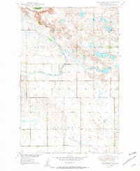
1950 Map of Brantford NE
USGS Topo · Published 1950About this map
The Sheyenne River winds through the northwestern corner of this Eddy County landscape, carved into the broad expanse of Tiffany Flats. This 1950 edition captures the rural layout of the region just as topographic work was being finalized for the development of the Missouri River Basin. The area is defined by its glacial hydrology, featuring substantial water bodies like Washington Lake and Cherry Lake, which are connected by a network of drainage features including Robinson Coulee.
Find a feature on this map
11 named features on this map. Tap any name to fly to it.
Don’t see what you’re looking for? This feature index may not catch every label — zoom into the map to look around manually.
Map Details
Editions of this 1950 Brantford NE Map
3 editions found
Other maps of this area

1928 · Tokio
USGS Topo · 1:62,500

1930 · Hamar
USGS Topo · 1:62,500

1931 · Tokio
USGS Topo · 1:62,500

1944 · Brantford
USGS Topo · 1:62,500

1946 · Brantford
USGS Topo · 1:62,500

1949 · Grace City
USGS Topo · 1:24,000

1950 · Brantford NW
USGS Topo · 1:24,000

1950 · Grace City
USGS Topo · 1:24,000

1950 · Brantford
USGS Topo · 1:24,000

1950 · Brantford NE
USGS Topo · 1:24,000