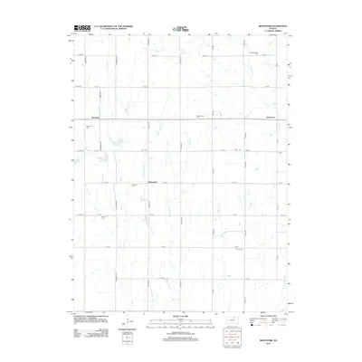
2012 Map of Brantford
USGS Topo · Published 2012About this map
The agrarian landscape of Washington County is defined by a grid of rural roads and the meandering drainage of the Scribner Cr and Parsons Cr basins. Small settlements such as Brantford and Calderhead serve as historical anchors for the surrounding farming community. The area is notable for its high density of community burial grounds, which reflect the early denominational and family settlement patterns of the region. From the Saint Bernards Cem in the northeast to the Rusco Cem further south, these sites along with Zion Cem and Covenant Cem offer significant touchpoints for genealogical research. The map captures the enduring rural character of the plains, where landmarks like Strawberry remain connected by established routes like Bismark Rd and Meridian Rd.
Find a feature on this map
33 named features on this map. Tap any name to fly to it.
Don’t see what you’re looking for? This feature index may not catch every label — zoom into the map to look around manually.
Map Details
Editions of this 2012 Brantford Map
This is the sole edition of this map. No revisions or reprints were ever made.
Other maps of this area

1893 · Washington
USGS Topo · 1:125,000

1955 · Manhattan
USGS Topo · 1:250,000

1956 · Manhattan
USGS Topo · 1:250,000

1957 · Manhattan
USGS Topo · 1:250,000

1965 · Clifton
USGS Topo · 1:24,000

1965 · Brantford
USGS Topo · 1:24,000
1965 · Clyde
USGS Topo · 1:24,000

1965 · Agenda
USGS Topo · 1:24,000

1966 · Morrowville
USGS Topo · 1:24,000
1966 · Haddam
USGS Topo · 1:24,000