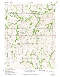
1966 Map of Haddam
USGS Topo · Published 1967About this map
Haddam serves as the central hub of this northern Kansas landscape, situated where the Chicago Burlington and Quincy railroad intersects a network of drainage basins. The map illustrates a deeply dissected agricultural terrain defined by the dendritic patterns of Mill Creek, Hay Valley Creek, and Mulberry Creek. Local landmarks like the Water Tank in town and the Adee Landing Strip to the south reflect the region's mid-century rural infrastructure. Genealogists will find notable burial sites including Haddam Cem and the more isolated Oliver Cem. The industrial footprint of the 1960s is represented by several Gravel Pits and a Quarry, while significant energy infrastructure is marked by multiple pipelines traversing the townships of Haddam, Grant, and Coleman. This survey records the distinct border between Republic Co and Washington Co, tracing how the land was organized for farming and transport before later 20th-century consolidations.
Find a feature on this map
24 named features on this map. Tap any name to fly to it.
Don’t see what you’re looking for? This feature index may not catch every label — zoom into the map to look around manually.
Map Details
Editions of this 1966 Haddam Map
This is the sole edition of this map. No revisions or reprints were ever made.
Other maps of this area

1893 · Washington
USGS Topo · 1:125,000

1955 · Manhattan
USGS Topo · 1:250,000

1956 · Manhattan
USGS Topo · 1:250,000

1957 · Manhattan
USGS Topo · 1:250,000

1965 · Brantford
USGS Topo · 1:24,000

1965 · Agenda
USGS Topo · 1:24,000
1966 · Washington NW
USGS Topo · 1:24,000

1966 · Morrowville
USGS Topo · 1:24,000
1966 · Narka
USGS Topo · 1:24,000
1966 · Cuba
USGS Topo · 1:24,000