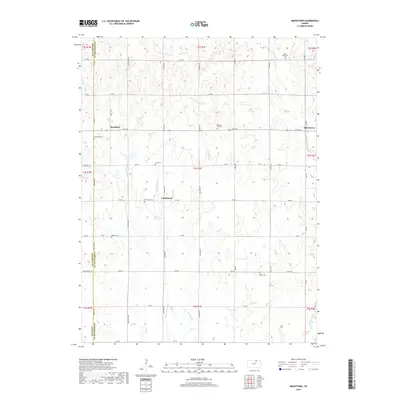
2018 Map of Brantford
USGS Topo · Published 2018About this map
Brantford and the rural crossroads of Calderhead anchor this 2018 survey of the Kansas plains along the border of Washington, Republic, and Cloud counties. The landscape is defined by the headwaters of several drainages, including Parsons Cr and the W Br Scribner Cr, which carve shallow valleys through the agricultural grid. A high concentration of cemeteries, such as Saint Bernard's Cem, Pleasant Hill Cem, and Zion Cem, suggests a deeply rooted community and the historical locations of early churches and parish centers that once served these dispersed farmsteads. The eastern edge of the quadrangle includes the small settlement of Strawberry, situated near the confluence of local tributaries. This survey captures the enduring rural infrastructure of the region, where a dense network of township roads like Meridian Rd and Bismark Rd continues to facilitate the movement of goods and people across the high plains.
Find a feature on this map
44 named features on this map. Tap any name to fly to it.
Don’t see what you’re looking for? This feature index may not catch every label — zoom into the map to look around manually.
Map Details
Editions of this 2018 Brantford Map
This is the sole edition of this map. No revisions or reprints were ever made.
Other maps of this area

1893 · Washington
USGS Topo · 1:125,000

1955 · Manhattan
USGS Topo · 1:250,000

1956 · Manhattan
USGS Topo · 1:250,000

1957 · Manhattan
USGS Topo · 1:250,000

1965 · Clifton
USGS Topo · 1:24,000

1965 · Brantford
USGS Topo · 1:24,000
1965 · Clyde
USGS Topo · 1:24,000

1965 · Agenda
USGS Topo · 1:24,000

1966 · Morrowville
USGS Topo · 1:24,000
1966 · Haddam
USGS Topo · 1:24,000