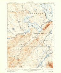
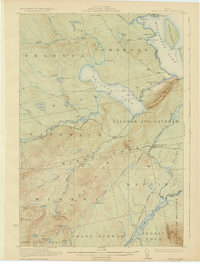
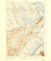
1923 Map of Brassua Lake
USGS Topo · Published 1936About this map
Brassua Lake and the western shores of Moosehead Lake dominate this 1920s landscape, illustrating a remote Maine wilderness shaped by timber and early rail. The crossing of the Canadian Pacific and Maine Central railroads at Somerset Junction provided a critical transport hub for the region's camps and farms. Smaller settlements and outposts like Brassua, Mackamp, and Tarratine PO are visible alongside the rail lines, while logging and sporting interests are represented by numerous named camps, including Page Camp and Warren Camp. The terrain is punctuated by significant elevations such as Blue Ridge and Big Squaw Mountain, with the Kennebec River East Outlet draining the massive lakes. Local education is evidenced by the Blaine School near the Moose River, serving the isolated families at Cornish Farm and Milliken Farm.
Find a feature on this map
70 named features on this map. Tap any name to fly to it.
Don’t see what you’re looking for? This feature index may not catch every label — zoom into the map to look around manually.
Map Details
Editions of this 1923 Brassua Lake Map
4 editions found
Other maps of this area

1905 · The Forks
USGS Topo · 1:62,500

1907 · The Forks
USGS Topo · 1:62,500

1920 · Moosehead Lake
USGS Topo · 1:62,500

1921 · Brassua Lake
USGS Topo · 1:62,500
1922 · Moosehead Lake
USGS Topo · 1:62,500

1922 · Long Pond
USGS Topo · 1:62,500

1923 · Brassua Lake
USGS Topo · 1:62,500

1924 · Long Pond
USGS Topo · 1:62,500

1925 · Pierce Pond
USGS Topo · 1:48,000

1927 · Pierce Pond
USGS Topo · 1:62,500
Featured Places
- Misery Gore, ME
- Tomhegan Township, ME
- Sapling Township, ME
- Big Moose Township, ME
- Tarratine, Taunton & Raynham Academy Grant