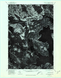
1977 Map of Brassua Lake West
USGS Topo · Published 1981About this map
Brassua Lake dominates the eastern portion of this 1977 orthophotoquad, showing the intricate shoreline and surrounding timberlands of Somerset County. This specialized imagery, captured from an aerial photograph on November 1, 1977, provides a direct look at the vegetation patterns and water levels of the era. The hydrology of the region is defined by the Moose River and the confluence of the North Branch and South Branch feeding into Brassua Stream. Notable elevations like Tom Fletcher Hill rise above the wetlands and smaller water bodies such as Demo Pond and Little Brassua Lake. The map reveals a landscape managed for natural resources, with clearings and access routes visible through the dense forest canopy, centered around the primary drainage systems and the southern reaches of the main lake.
Find a feature on this map
9 named features on this map. Tap any name to fly to it.
Don’t see what you’re looking for? This feature index may not catch every label — zoom into the map to look around manually.
Map Details
Editions of this 1977 Brassua Lake West Map
This is the sole edition of this map. No revisions or reprints were ever made.
Other maps of this area

1921 · Brassua Lake
USGS Topo · 1:62,500

1922 · Long Pond
USGS Topo · 1:62,500

1923 · Brassua Lake
USGS Topo · 1:62,500

1924 · Long Pond
USGS Topo · 1:62,500

1944 · Brassua Lake
USGS Topo · 1:62,500

1944 · Long Pond
USGS Topo · 1:62,500

1949 · Jackman
USGS Topo · 1:250,000

1954 · Seboomook Lake
USGS Topo · 1:62,500

1954 · Millinocket
USGS Topo · 1:250,000

1956 · Penobscot Lake
USGS Topo · 1:62,500
Featured Places
- Tomhegan Township, ME
- Sandwich Academy Grant Township, ME
- Rockwood Strip T1 R1 NBKP, ME
- Brassua, Sandwich Academy Grant Township
- Brassua Township, ME