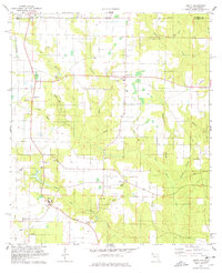
1978 Map of Bratt
USGS Topo · Published 1978About this map
Agricultural lands and pine-rimmed drainage basins characterize this borderland where the Alabama-Florida state line divides Escambia County. The settlement of Bratt serves as a central hub, supported by a network of rural institutions like Shiloh Ch and Middle Sch. To the west, the ST Louis-San Francisco railroad cuts a straight path through the landscape near Walnut Hill, reflecting the region's reliance on rail for transporting timber or farm goods.
Find a feature on this map
36 named features on this map. Tap any name to fly to it.
Don’t see what you’re looking for? This feature index may not catch every label — zoom into the map to look around manually.
Map Details
Editions of this 1978 Bratt Map
This is the sole edition of this map. No revisions or reprints were ever made.
Other maps of this area

1941 · Century
USGS Topo · 1:62,500

1942 · Perdido
USGS Topo · 1:62,500

1942 · Dyas
USGS Topo · 1:62,500

1943 · Century
USGS Topo · 1:62,500

1944 · Dyas
USGS Topo · 1:62,500

1944 · Perdido
USGS Topo · 1:62,500

1953 · Andalusia
USGS Topo · 1:250,000

1957 · Andalusia
USGS Topo · 1:250,000

1957 · Pensacola
USGS Topo · 1:250,000

1959 · Pensacola
USGS Topo · 1:250,000