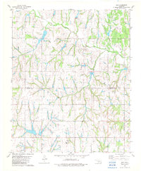
1982 Map of Bray
USGS Topo · Published 1982About this map
Bray and the surrounding plains of the Grady County and Stephens County line are defined here by a network of seasonal watercourses and petroleum development in the early 1980s. The landscape is carved by Rush Creek and its many tributaries, including Fourmile Creek and Coon Creek, which create a complex system of draws and low ridges. The township of Bailey sits north of the corporate limits of Bray, while the community of Wall occupies the southwestern portion of the sheet. Grounded local-history details include the Bray Church and a rural Cemetery, alongside numerous markers for a Gas Well or Oil Field that speak to the region's energy economy. This survey documents the intersection of agricultural land and the resource extraction that shaped central Oklahoma's rural character during this era.
Find a feature on this map
19 named features on this map. Tap any name to fly to it.
Don’t see what you’re looking for? This feature index may not catch every label — zoom into the map to look around manually.
Map Details
Editions of this 1982 Bray Map
This is the sole edition of this map. No revisions or reprints were ever made.
Other maps of this area

1902 · Rush Springs
USGS Topo · 1:125,000

1949 · Rush Springs
USGS Topo · 1:62,500

1950 · Rush Springs
USGS Topo · 1:62,500

1950 · Marlow
USGS Topo · 1:62,500

1951 · Marlow
USGS Topo · 1:62,500

1957 · Ardmore
USGS Topo · 1:250,000

1963 · Ardmore
USGS Topo · 1:250,000

1966 · Lindsay SW
USGS Topo · 1:24,000
1974 · Cox City
USGS Topo · 1:24,000
1974 · Lake Fuqua
USGS Topo · 1:24,000