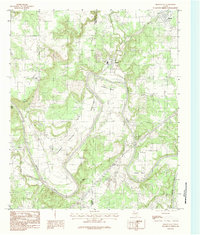
1984 Map of Brazos East
USGS Topo · Published 1984About this map
The Brazos River carves a winding path through the borderlands of Palo Pinto and Parker counties, defining a landscape of dramatic oxbows and named overlooks. In this early 1980s documentation, the river's serpentine course is punctuated by several prominent features like Littlefield Bend, Meeks Bend, and Polk Stalk Bend, while Inspiration Point and Arleburn Point offer high-elevation views over the valley floor. The settlement of Millsap occupies the northeastern corner, contrasted by the industrial presence of Gravel Pits and a Filtration Plant near Bennett. Land use in the broad Dobbs Valley and Gilbert Valley reflects the region's agricultural and resource-based economy. Significant watercourses including Palo Pinto Creek, Rock Creek, and Grassy Branch feed into the main river, illustrating the complex drainage network of this Texas terrain.
Find a feature on this map
23 named features on this map. Tap any name to fly to it.
Don’t see what you’re looking for? This feature index may not catch every label — zoom into the map to look around manually.
Map Details
Editions of this 1984 Brazos East Map
This is the sole edition of this map. No revisions or reprints were ever made.
Other maps of this area

1891 · Weatherford
USGS Topo · 1:125,000

1891 · Palo Pinto
USGS Topo · 1:125,000

1893 · Weatherford
USGS Topo · 1:125,000

1918 · Palo Pinto
USGS Topo · 1:125,000

1925 · Palo Pinto 4-b
USGS Topo · 1:48,000

1927 · Mineral Wells
USGS Topo · 1:62,500

1931 · Dennis
USGS Topo · 1:62,500

1931 · Santo
USGS Topo · 1:62,500

1954 · Dallas
USGS Topo · 1:250,000

1954 · Abilene
USGS Topo · 1:250,000