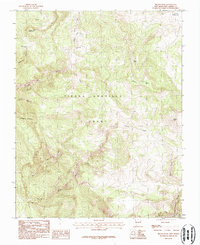
1983 Map of Brazos Peak
USGS Topo · Published 1987About this map
The Tierra Amarilla Grant dominates this northern New Mexico landscape, a massive tract of land surveyed here in the late 1970s and early 1980s. The terrain is defined by dramatic vertical relief, ranging from the heights of Brazos Peak and Sugar Loaf Mountain to the sheer drop of the Brazos Cliffs in the southeast. Water follows steep descent patterns through complex drainage systems, including Chavez Creek and the West Fork Chavez Creek, which carve out deep geological features like the Chavez Box.
Find a feature on this map
20 named features on this map. Tap any name to fly to it.
Don’t see what you’re looking for? This feature index may not catch every label — zoom into the map to look around manually.
Map Details
Editions of this 1983 Brazos Peak Map
Other maps of this area

1918 · Tusas
USGS Topo · 1:125,000

1954 · Aztec
USGS Topo · 1:250,000

1955 · Chama
USGS Topo · 1:62,500

1955 · Cebolla
USGS Topo · 1:62,500

1955 · Brazos Peak
USGS Topo · 1:62,500

1955 · Tierra Amarilla
USGS Topo · 1:62,500

1958 · Aztec
USGS Topo · 1:250,000

1962 · Aztec
USGS Topo · 1:250,000

1965 · Aztec
USGS Topo · 1:250,000

1981 · Chama
USGS Topo · 1:100,000