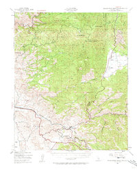
1943 Map of Breckenridge Mtn
USGS Topo · Published 1963About this map
The Kern River carves through the northwestern corner of this landscape, marking a transition into the high elevations of the Sequoia National Forest. This 1943 survey captures a rural Kern County economy defined by cattle ranching and early industrial sites, centered around the high-altitude Walker Basin and the prominent Breckenridge Mountain. Settlement is sparse and largely focused on family-held lands such as Williams Ranch and Rankin Ranch, while the presence of the Tungsten Chief Mill points to the area's strategic mineral extraction during the war era.
Find a feature on this map
51 named features on this map. Tap any name to fly to it.
Don’t see what you’re looking for? This feature index may not catch every label — zoom into the map to look around manually.
Map Details
Editions of this 1943 Breckenridge Mtn Map
4 editions found

Other maps of this area

1906 · Kernville
USGS Topo · 1:125,000

1908 · Kernville
USGS Topo · 1:125,000

1914 · Caliente
USGS Topo · 1:125,000

1915 · Mojave
USGS Topo · 1:125,000

1920 · Delonagha
USGS Topo · 1:62,500

1926 · Glennville
USGS Topo · 1:62,500

1929 · Bena
USGS Topo · 1:31,680

1930 · Bear Mountain
USGS Topo · 1:31,680

1930 · Arvin
USGS Topo · 1:31,680

1931 · Edison
USGS Topo · 1:31,680