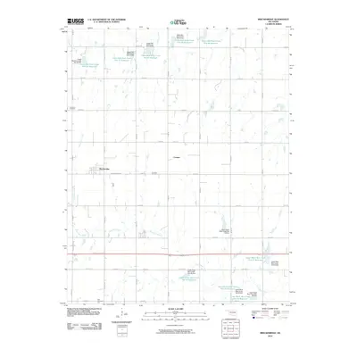
2010 Map of Breckinridge
USGS Topo · Published 2010About this map
Breckinridge and the small crossroads of Cropper anchor this section of Garfield County, Oklahoma, defined by a landscape of engineered water management and agricultural grid lines. The terrain is marked by a sophisticated system of flood control, featuring numerous reservoirs and dams such as the Upper Red Rock Creek Site 33 Reservoir to the north and the Upper Black Bear Creek Site 31 Reservoir in the southeast. These man-made features surround the natural drainages of Red Rock Creek and Black Bear Creek. Genealogists and local historians will find significant value in the distribution of several rural burial grounds, including Immanuel Cemetery in the northwest, Paradise Cemetery near the center, and Zion Cemetery in the southwest corner. The road network reflects a mix of modern county routes and older thoroughfares like Old Hwy 64, tracing the evolution of regional transportation through the plains.
Find a feature on this map
51 named features on this map. Tap any name to fly to it.
Don’t see what you’re looking for? This feature index may not catch every label — zoom into the map to look around manually.
Map Details
Editions of this 2010 Breckinridge Map
This is the sole edition of this map. No revisions or reprints were ever made.
Other maps of this area

1955 · Enid East
USGS Topo · 1:24,000

1955 · Enid
USGS Topo · 1:250,000

1956 · Garber
USGS Topo · 1:62,500

1956 · Enid
USGS Topo · 1:62,500

1958 · Enid
USGS Topo · 1:250,000

1968 · Lamont SE
USGS Topo · 1:24,000

1968 · Hunter
USGS Topo · 1:24,000

1968 · Kremlin
USGS Topo · 1:24,000
1982 · Garber
USGS Topo · 1:24,000
1982 · Enid SE
USGS Topo · 1:24,000