
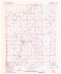
1968 Map of Kremlin
USGS Topo · Published 1970About this map
Kremlin and the surrounding Garfield County countryside are defined by a mix of agricultural landscape and industrial utility during the late 1960s. The town sits as a primary hub along the Chicago Rock Island and Pacific railroad line, which bisects the region. This transportation corridor is punctuated by specialized facilities such as the Carbon Plant and the Zaloudek Landing Strip, signaling a diversified local economy that moved beyond simple farming. The terrain is drained by Wild Horse Creek and Sand Creek, with the natural topography carefully managed through features like the Sewage Disposal Ponds and a Gaging Station. For those researching local heritage, the map identifies significant sites such as the Valley Center Cem and Kremlin Cem, alongside numerous Oil Wells, Gas Wells, and a Shale Pit that highlight the area's extraction history.
Find a feature on this map
22 named features on this map. Tap any name to fly to it.
Don’t see what you’re looking for? This feature index may not catch every label — zoom into the map to look around manually.
Map Details
Editions of this 1968 Kremlin Map
2 editions found
Other maps of this area

1955 · Enid West
USGS Topo · 1:24,000

1955 · Enid East
USGS Topo · 1:24,000

1955 · Enid
USGS Topo · 1:250,000

1956 · Garber
USGS Topo · 1:62,500

1956 · Enid
USGS Topo · 1:62,500

1958 · Enid
USGS Topo · 1:250,000

1968 · Hillsdale
USGS Topo · 1:24,000

1968 · Lamont NW
USGS Topo · 1:24,000

1968 · Hunter
USGS Topo · 1:24,000

1968 · Pond Creek
USGS Topo · 1:24,000