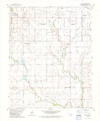
1982 Map of Enid SE
USGS Topo · Published 1983About this map
The southeast outskirts of Enid are defined by a mix of agricultural township land and industrial development during the early 1980s. Local transit and community life center around the Burlington Northern rail line and the Pioneer-Pleasantvale Sch located near Pioneer Community Park. This landscape reveals the importance of natural resource extraction, with a significant Oil And Gas Field and scattered Gravel Pits marking the terrain between the meandering flows of Skeleton Creek and Hackberry Creek.
Find a feature on this map
20 named features on this map. Tap any name to fly to it.
Don’t see what you’re looking for? This feature index may not catch every label — zoom into the map to look around manually.
Map Details
Editions of this 1982 Enid SE Map
This is the sole edition of this map. No revisions or reprints were ever made.
Other maps of this area

1893 · Lovell
USGS Topo · 1:62,500

1893 · Hennessey
USGS Topo · 1:62,500

1955 · Enid West
USGS Topo · 1:24,000

1955 · Enid East
USGS Topo · 1:24,000

1955 · Enid
USGS Topo · 1:250,000

1956 · Garber
USGS Topo · 1:62,500

1956 · Hennessey
USGS Topo · 1:62,500

1956 · Enid
USGS Topo · 1:62,500

1958 · Enid
USGS Topo · 1:250,000

1974 · Marshall West
USGS Topo · 1:24,000