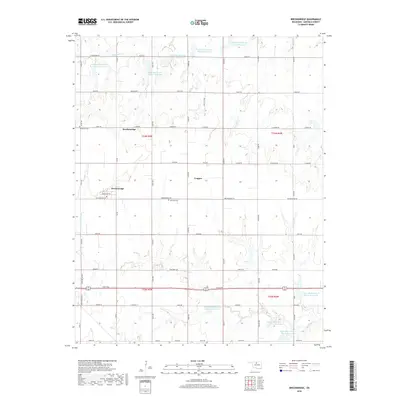
2018 Map of Breckinridge
USGS Topo · Published 2018About this map
Breckenridge and the nearby locale of Cropper anchor this prairie landscape in Garfield County, defined by a meticulously surveyed grid of township and range lines. The terrain is notably managed by a series of water control structures, including the Upper Red Rock Cr Site 31 Reservoir and several similar sites along the branches of Black Bear Cr. For those tracing local heritage, the map identifies Immanuel Cem and Paradise Cem, alongside family-named routes such as Hare Mahaffery and Hellums RD. The settlement pattern follows a strict section-line road network, where primary routes like Breckenridge RD and Market ST connect the farming community. The landscape reflects a sophisticated system of watershed management, as evidenced by the numerous reservoirs flanking Red Rock Cr, which stand in contrast to the traditional rural infrastructure of the Oklahoma plains.
Find a feature on this map
60 named features on this map. Tap any name to fly to it.
Don’t see what you’re looking for? This feature index may not catch every label — zoom into the map to look around manually.
Map Details
Editions of this 2018 Breckinridge Map
This is the sole edition of this map. No revisions or reprints were ever made.
Other maps of this area

1955 · Enid East
USGS Topo · 1:24,000

1955 · Enid
USGS Topo · 1:250,000

1956 · Garber
USGS Topo · 1:62,500

1956 · Enid
USGS Topo · 1:62,500

1958 · Enid
USGS Topo · 1:250,000

1968 · Lamont SE
USGS Topo · 1:24,000

1968 · Hunter
USGS Topo · 1:24,000

1968 · Kremlin
USGS Topo · 1:24,000
1982 · Garber
USGS Topo · 1:24,000
1982 · Enid SE
USGS Topo · 1:24,000