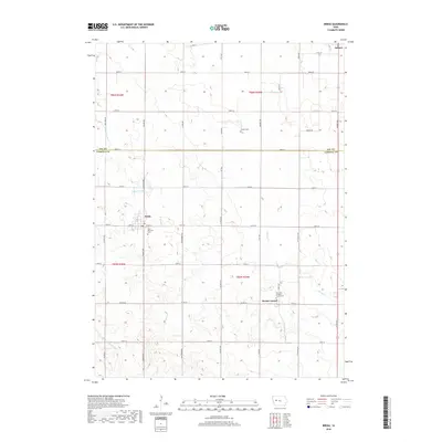
2018 Map of Breda
USGS Topo · Published 2018About this map
Breda and Mount Carmel anchor this agricultural landscape along the northern border of Carroll County, Iowa. The region is defined by a rigorous section-line road grid, including Granite Ave and Kittyhawk Ave, which navigate the subtle drainage basins of the Middle Raccoon River and Storm Creek. These waterways, along with the Wall Lake Inlet, provided the foundational hydrology for the surrounding farmsteads. Local genealogy is well-represented by several religious and family landmarks, such as Saint Bernards Cemetery in Breda and Our Lady of Mount Carmel Cemetery. Further north across the county line into Sac County, the settlement of Auburn appears at the map's edge, while the isolated Luckow Cemetery sits among the fields, marking the legacy of early families in the township.
Find a feature on this map
44 named features on this map. Tap any name to fly to it.
Don’t see what you’re looking for? This feature index may not catch every label — zoom into the map to look around manually.
Map Details
Editions of this 2018 Breda Map
This is the sole edition of this map. No revisions or reprints were ever made.
Other maps of this area

1954 · Fort Dodge
USGS Topo · 1:250,000

1957 · Fort Dodge
USGS Topo · 1:250,000

1958 · Fort Dodge
USGS Topo · 1:250,000

1980 · Breda
USGS Topo · 1:24,000

1980 · Grant City
USGS Topo · 1:24,000

1980 · Carroll NE
USGS Topo · 1:24,000

1980 · Yetter
USGS Topo · 1:24,000

1980 · Lake View
USGS Topo · 1:24,000
1980 · Carroll West
USGS Topo · 1:24,000
1980 · Carroll East
USGS Topo · 1:24,000