
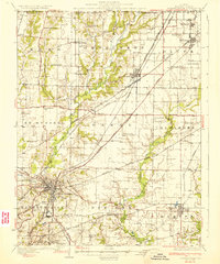
1907 Map of Breese
USGS Topo · Published 1937About this map
Sugar Creek and Shoal Creek define the drainage of this Illinois landscape, which was characterized by a dense network of early 20th-century rural schools and growing railroad towns. Large settlements like Highland and Breese are shown with their detailed street grids, while smaller hubs such as Sebastopol and St Rose serve the surrounding farming townships. The map illustrates a heavy reliance on rail transport, featuring the Baltimore and Ohio Southwestern RR, the Southern RR, and the Vandalia Line.
Find a feature on this map
66 named features on this map. Tap any name to fly to it.
Don’t see what you’re looking for? This feature index may not catch every label — zoom into the map to look around manually.
Map Details
Editions of this 1907 Breese Map
2 editions found
Other maps of this area

1906 · Breese
USGS Topo · 1:62,500

1907 · Breese
USGS Topo · 1:62,500

1907 · Belleville
USGS Topo · 1:62,500

1910 · Carlyle
USGS Topo · 1:62,500

1910 · Okawville
USGS Topo · 1:62,500

1912 · New Athens
USGS Topo · 1:62,500

1927 · Edwardsville
USGS Topo · 1:62,500

1931 · Hoyleton
USGS Topo · 1:48,000
1932 · Edwardsville
USGS Topo · 1:62,500
1932 · Greenville
USGS Topo · 1:62,500