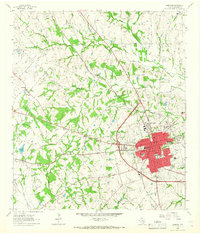
1963 Map of Brenham
USGS Topo · Published 1966About this map
The regional hub of Brenham serves as the focal point for this mid-century survey, showing the city's growth around the intersection of the Southern Pacific and the Atchison Topeka and Santa Fe railroads. The landscape is defined by a dense network of family-named cemeteries and small rural congregations, including Heisig Cem, Eichholt Cem, and Mount Pilgrim Ch. A particularly somber historical marker is found in the Yellow Fever Cem located just north of the city limits, a site that underscores the public health challenges of previous generations.
Find a feature on this map
49 named features on this map. Tap any name to fly to it.
Don’t see what you’re looking for? This feature index may not catch every label — zoom into the map to look around manually.
Map Details
Editions of this 1963 Brenham Map
3 editions found
Other maps of this area

1914 · Gay Hill
USGS Topo · 1:62,500

1930 · Brenham
USGS Topo · 1:62,500

1954 · Austin
USGS Topo · 1:250,000

1956 · Brenham
USGS Topo · 1:62,500

1956 · Somerville
USGS Topo · 1:62,500

1958 · Greenvine
USGS Topo · 1:24,000

1958 · Burton
USGS Topo · 1:24,000

1959 · Gay Hill
USGS Topo · 1:24,000

1959 · Somerville
USGS Topo · 1:24,000

1959 · Independence
USGS Topo · 1:24,000