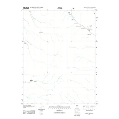
2012 Map of Brewer Canyon
USGS Topo · Published 2012About this map
Washington sits along the southwestern reaches of this Nye County landscape, where Washington Creek flows near the Washington Creek Trailhead. The topography is defined by a series of deep drainages, including Brewer Canyon, Porter Canyon, and Crane Canyon, which channel seasonal water from high peaks such as Bunker Hill. In the northeast, the presence of the Kingston Canyon Dam on Kingston Creek forms Groves Lake, a key water feature in this arid environment. This area reflects a long-standing ranching and outdoor heritage, anchored by locations like the Daniel Ranch and Daniels. Moving south and east, the map details numerous named waterways such as Knox Creek, Clear Creek, and Cottonwood Creek, alongside the Kingston Campground, illustrating the transition from ranching operations to modern recreational access in the Toiyabe region.
Find a feature on this map
24 named features on this map. Tap any name to fly to it.
Don’t see what you’re looking for? This feature index may not catch every label — zoom into the map to look around manually.
Map Details
Editions of this 2012 Brewer Canyon Map
This is the sole edition of this map. No revisions or reprints were ever made.
Other maps of this area

1955 · Millett
USGS Topo · 1:250,000

1956 · North Shoshone Peak
USGS Topo · 1:62,500

1956 · Millett Ranch
USGS Topo · 1:62,500

1956 · Austin
USGS Topo · 1:62,500

1959 · Millett
USGS Topo · 1:250,000

1969 · Dutch Flat
USGS Topo · 1:24,000

1985 · Smith Creek Valley
USGS Topo · 1:100,000
1988 · East of Millett Ranch
USGS Topo · 1:24,000
1988 · Bunker Hill
USGS Topo · 1:24,000
1988 · North Toiyabe Peak
USGS Topo · 1:24,000