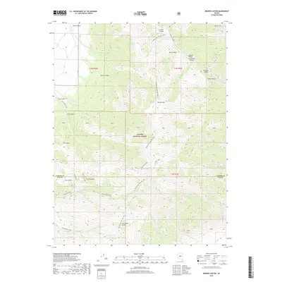
2018 Map of Brewer Canyon
USGS Topo · Published 2018About this map
Toiyabe National Forest dominates this high-elevation terrain where the border between Lander and Nye Counties runs through steep ridges and deep drainages. The landscape is defined by its complex watershed, with Washington Creek, Carseley Creek, and Cottonwood Creek 1 carving paths through the massive slopes of the Toiyabe Range. Higher elevations are marked by landmarks like Bunker Hill and Groves Lake, providing a clear look at the drainage patterns that feed into the valley floors.
Find a feature on this map
42 named features on this map. Tap any name to fly to it.
Don’t see what you’re looking for? This feature index may not catch every label — zoom into the map to look around manually.
Map Details
Editions of this 2018 Brewer Canyon Map
This is the sole edition of this map. No revisions or reprints were ever made.
Other maps of this area

1955 · Millett
USGS Topo · 1:250,000

1956 · North Shoshone Peak
USGS Topo · 1:62,500

1956 · Millett Ranch
USGS Topo · 1:62,500

1956 · Austin
USGS Topo · 1:62,500

1959 · Millett
USGS Topo · 1:250,000

1969 · Dutch Flat
USGS Topo · 1:24,000

1985 · Smith Creek Valley
USGS Topo · 1:100,000
1988 · East of Millett Ranch
USGS Topo · 1:24,000
1988 · Bunker Hill
USGS Topo · 1:24,000
1988 · North Toiyabe Peak
USGS Topo · 1:24,000