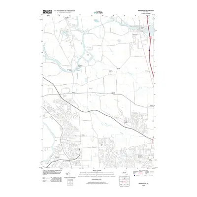
2010 Map of Brewerton
USGS Topo · Published 2010About this map
Brewerton and the town of Clay occupy a landscape defined by the confluence of the Oneida River and the Seneca River, just west of Oneida Lake. The region is characterized by low-lying waterways and significant marshlands, most notably the Peat Swamp that stretches across the center of the sheet. Islands such as Schroeppel Island and Glosky Island sit within the winding river channels, accessible by crossings like the Schroeppel Bridge.
Find a feature on this map
63 named features on this map. Tap any name to fly to it.
Don’t see what you’re looking for? This feature index may not catch every label — zoom into the map to look around manually.
Map Details
Editions of this 2010 Brewerton Map
This is the sole edition of this map. No revisions or reprints were ever made.
Other maps of this area

1895 · Syracuse
USGS Topo · 1:62,500

1898 · Syracuse
USGS Topo · 1:62,500

1900 · Baldwinsville
USGS Topo · 1:62,500

1900 · Fulton
USGS Topo · 1:62,500

1905 · Mexico
USGS Topo · 1:62,500

1938 · Syracuse East
USGS Topo · 1:24,000

1939 · Syracuse West
USGS Topo · 1:24,000

1940 · Brewerton
USGS Topo · 1:24,000

1940 · Cicero
USGS Topo · 1:24,000
1943 · Syracuse East
USGS Topo · 1:31,680