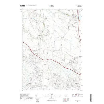
2019 Map of Brewerton
USGS Topo · Published 2019About this map
Oneida Lake and the Oneida River form the natural northern boundary of this central New York landscape, marking the historic divide between Oswego and Onondaga counties. The settlement of Brewerton anchors the northeastern corner where the river exits the lake, while the suburban expansion of North Syracuse and Elmcrest occupies the southern reaches. The interior terrain is defined by a network of small waterways like Shaver Creek and Youngs Creek, which flow through low-lying areas such as Peat Swamp. This 2019 survey documents a mix of established rural crossroads like Euclid and Clay alongside newer residential subdivisions and private aviation facilities like Riveredge Airpark. Genealogists will find several burial grounds mapped across the territory, including Riverside Cem and Morgan's Cem, reflecting the area's long history of settlement near the river forks.
Find a feature on this map
248 named features on this map. Tap any name to fly to it.
Don’t see what you’re looking for? This feature index may not catch every label — zoom into the map to look around manually.
Map Details
Editions of this 2019 Brewerton Map
This is the sole edition of this map. No revisions or reprints were ever made.
Other maps of this area

1895 · Syracuse
USGS Topo · 1:62,500

1898 · Syracuse
USGS Topo · 1:62,500

1900 · Baldwinsville
USGS Topo · 1:62,500

1900 · Fulton
USGS Topo · 1:62,500

1905 · Mexico
USGS Topo · 1:62,500

1938 · Syracuse East
USGS Topo · 1:24,000

1939 · Syracuse West
USGS Topo · 1:24,000

1940 · Brewerton
USGS Topo · 1:24,000

1940 · Cicero
USGS Topo · 1:24,000
1943 · Syracuse East
USGS Topo · 1:31,680