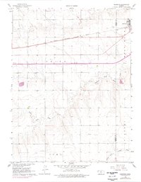
1966 Map of Brewster
USGS Topo · Published 1977About this map
Brewster serves as the primary hub of this High Plains landscape, situated along the Chicago Rock Island and Pacific railroad. This survey, updated with 1974 aerial data, reveals a high-altitude agricultural grid defined by township and range lines across Thomas and Sherman counties. The settlement pattern is largely influenced by the drainage of the South Fork Sappa Creek in the central portion of the quadrangle and the South Fork Solomon River to the south. Local history is anchored at the Brewster Cem just outside the town limits and the Fairview Cem to the northwest. The terrain is marked by numerous well sites and a system of field lines, reflecting the intensive land use of mid-century Kansas farming communities.
Find a feature on this map
12 named features on this map. Tap any name to fly to it.
Don’t see what you’re looking for? This feature index may not catch every label — zoom into the map to look around manually.
Map Details
Editions of this 1966 Brewster Map
2 editions found
Other maps of this area

1954 · Goodland
USGS Topo · 1:250,000

1956 · Goodland
USGS Topo · 1:250,000

1957 · Goodland
USGS Topo · 1:250,000

1959 · Harris Draw
USGS Topo · 1:62,500

1966 · Edson
USGS Topo · 1:24,000

1966 · Goodland NE
USGS Topo · 1:24,000

1966 · Brewster NW
USGS Topo · 1:24,000

1966 · Brewster
USGS Topo · 1:24,000

1966 · Brewster SE
USGS Topo · 1:24,000

1967 · Brewster NE
USGS Topo · 1:24,000