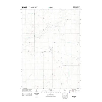
2013 Map of Bricelyn
USGS Topo · Published 2013About this map
Bricelyn serves as the central hub of this agricultural landscape in Faribault County, where the regular grid of township roads meets the winding course of the E Br Blue Earth River. The 2013 survey illustrates a highly managed water system, dominated by an extensive network of drainage infrastructure including County Ditch Number Fiftyfive, County Ditch Number Sixtyfour, and County Ditch Number Seventyone. This heavy reliance on ditching reflects the necessity of controlling the water table in this low-lying prairie region to support large-scale farming. Local history is anchored by the presence of Clayton Cem to the northwest and Bricelyn Cem just south of the town center. The landscape is also defined by Brush Cr, which meanders across the eastern half of the map, intersecting with the rigid lines of Co HWY-2 and various section-line roads.
Find a feature on this map
30 named features on this map. Tap any name to fly to it.
Don’t see what you’re looking for? This feature index may not catch every label — zoom into the map to look around manually.
Map Details
Editions of this 2013 Bricelyn Map
This is the sole edition of this map. No revisions or reprints were ever made.
Other maps of this area

1954 · Mason City
USGS Topo · 1:250,000

1955 · Bricelyn
USGS Topo · 1:62,500

1955 · Wells
USGS Topo · 1:62,500

1957 · Mason City
USGS Topo · 1:250,000

1958 · Mason City
USGS Topo · 1:250,000

1972 · Buffalo Center
USGS Topo · 1:24,000

1972 · Buffalo Center NE
USGS Topo · 1:24,000

1972 · Vinje
USGS Topo · 1:24,000
1982 · Bricelyn
USGS Topo · 1:24,000
1982 · Kiester
USGS Topo · 1:24,000