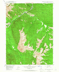
1948 Map of Bridal Veil Falls
USGS Topo · Published 1966About this map
Cascade Mountain and the towering ridges of the Uinta National Forest dominate this post-war survey of the Provo Canyon region. Along the narrow valley floor, the Provo River runs parallel to the Denver & Rio Grande Western R R and U.S. 189, supporting a string of small canyon settlements including Vivian Park, Springdell, and Wildwood. The landscape is defined by its dramatic verticality, from the Big Provo Cirque in the north to the iconic Bridal Veil Falls and Upper Falls.
Find a feature on this map
54 named features on this map. Tap any name to fly to it.
Don’t see what you’re looking for? This feature index may not catch every label — zoom into the map to look around manually.
Map Details
Editions of this 1948 Bridal Veil Falls Map
4 editions found
Other maps of this area

1885 · Salt Lake
USGS Topo · 1:250,000

1907 · Strawberry Valley
USGS Topo · 1:125,000

1909 · Strawberry Valley
USGS Topo · 1:125,000

1948 · Timpanogos Cave
USGS Topo · 1:24,000

1948 · Orem
USGS Topo · 1:24,000

1948 · Orem
USGS Topo · 1:62,500

1948 · Springville
USGS Topo · 1:24,000

1948 · Aspen Grove
USGS Topo · 1:24,000

1948 · Provo
USGS Topo · 1:24,000

1948 · Bridal Veil Falls
USGS Topo · 1:24,000