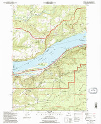
1994 Map of Bridal Veil
USGS Topo · Published 1996About this map
Bridal Veil sits at the heart of this mid-1990s survey, marking a point where the river economy and early recreational infrastructure converged. The map detail highlights the dramatic transition from the Columbia River shoreline up toward the high ridges of Pepper Mtn and Ross Mountain. This era preserves the extensive network of state parks and protected lands within the Columbia River Gorge National Scenic Area, documenting the careful management of landmark sites like Crown Point and the Vista House.
Find a feature on this map
54 named features on this map. Tap any name to fly to it.
Don’t see what you’re looking for? This feature index may not catch every label — zoom into the map to look around manually.
Map Details
Editions of this 1994 Bridal Veil Map
This is the sole edition of this map. No revisions or reprints were ever made.
Other maps of this area

1911 · Boring
USGS Topo · 1:48,000

1914 · Boring
USGS Topo · 1:62,500

1916 · Estacada
USGS Topo · 1:125,000

1918 · Troutdale
USGS Topo · 1:62,500

1934 · Troutdale
USGS Topo · 1:48,000

1940 · Boring
USGS Topo · 1:62,500

1941 · Camas
USGS Topo · 1:62,500

1942 · Camas
USGS Topo · 1:62,500

1948 · Vancouver
USGS Topo · 1:250,000

1950 · Vancouver
USGS Topo · 1:250,000