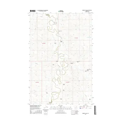
2017 Map of Bridge Coulee
USGS Topo · Published 2017About this map
The Musselshell River carves a complex, meandering path through this landscape along the border of Garfield and Petroleum Counties. Near the center of the survey lies Ross Hall, situated among a network of deep drainages including Bridge Coulee and Raundal Coulee. This terrain is defined by its numerous coulees, reflecting a landscape shaped by persistent erosion and seasonal water flow. To the north, the Gilfeather Cem and Gilfeather Rd provide evidence of early family ranching and local settlement history in this sparsely populated region.
Find a feature on this map
31 named features on this map. Tap any name to fly to it.
Don’t see what you’re looking for? This feature index may not catch every label — zoom into the map to look around manually.
Map Details
Editions of this 2017 Bridge Coulee Map
This is the sole edition of this map. No revisions or reprints were ever made.
Other maps of this area

1954 · Jordan
USGS Topo · 1:250,000

1954 · Lewistown
USGS Topo · 1:250,000

1956 · Jordan
USGS Topo · 1:250,000

1958 · Jordan
USGS Topo · 1:250,000

1959 · Lewistown
USGS Topo · 1:250,000

1964 · Jordan
USGS Topo · 1:250,000
1967 · Barney Pinnacle
USGS Topo · 1:24,000

1967 · Nelson Coulee
USGS Topo · 1:24,000
1967 · Fail Ranch
USGS Topo · 1:24,000
1967 · Lelig Coulee
USGS Topo · 1:24,000