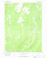
1967 Map of Bridger Lake
USGS Topo · Published 1975About this map
Wasatch National Forest dominates this high-altitude landscape along the border of Uinta and Summit Counties, where the High Uintas transition into southern Wyoming. The terrain is defined by the complex drainage of the Smiths Fork, including its East Fork and West Fork, which feed into numerous alpine water bodies like Bridger Lake and China Lake. The map reveals a mid-century infrastructure dedicated to forest management and recreation, marked by the Hewinta Guard Station and Bridger Lake Guard Station. A small cemetery near the northern boundary and names like Mansfield Meadows suggest early land use or family holdings preceding the more modern developments of the China Meadows Campground and Marsh Lake Campground. The presence of extensive pack trails and a Footbridge over the fork illustrates the reliance on traditional backcountry travel throughout this wilderness area during the late 1960s.
Find a feature on this map
36 named features on this map. Tap any name to fly to it.
Don’t see what you’re looking for? This feature index may not catch every label — zoom into the map to look around manually.
Map Details
Editions of this 1967 Bridger Lake Map
3 editions found
Other maps of this area

1885 · Uinta
USGS Topo · 1:250,000

1901 · Hayden Peak
USGS Topo · 1:125,000

1903 · Hayden Peak
USGS Topo · 1:125,000

1905 · Gilbert Peak
USGS Topo · 1:125,000

1906 · Gilbert Peak
USGS Topo · 1:125,000

1954 · Salt Lake City
USGS Topo · 1:250,000

1954 · Ogden
USGS Topo · 1:250,000

1958 · Ogden
USGS Topo · 1:250,000

1958 · Salt Lake City
USGS Topo · 1:250,000

1960 · Ogden
USGS Topo · 1:250,000