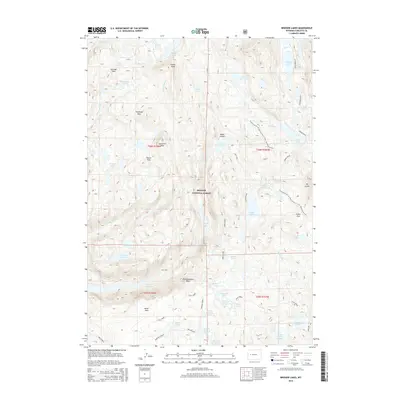
2015 Map of Bridger Lakes
USGS Topo · Published 2015About this map
Bridger National Forest defines the geography of this high-altitude landscape in the Wind River Range. The high-country terrain is punctuated by significant peaks including Guitierrez Peak and Duran Peak, which overlook a network of alpine basins and water bodies. The Continental Divide National Scenic Trail traverses the eastern half of the sheet, providing access to the glacial-carved Titcomb Basin and the expansive Titcomb Lakes. The mapping reveals a complex hydrological system where Fremont Creek and Bridger Creek drain numerous high-elevation lakes such as Island Lake, Seneca Lake, and the uniquely named Sauerkraut Lakes. Strategic mountain passes, including Gunsight Pass, Threlkeld Pass, and Lester Pass, indicate the historic corridors used to navigate this demanding vertical environment, while Photographers Point offers a recognized vantage over the surrounding wilderness.
Find a feature on this map
55 named features on this map. Tap any name to fly to it.
Don’t see what you’re looking for? This feature index may not catch every label — zoom into the map to look around manually.
Map Details
Editions of this 2015 Bridger Lakes Map
This is the sole edition of this map. No revisions or reprints were ever made.
Other maps of this area

1909 · Fremont Peak
USGS Topo · 1:125,000

1955 · Thermopolis
USGS Topo · 1:250,000

1955 · Lander
USGS Topo · 1:250,000

1958 · Lander
USGS Topo · 1:250,000

1958 · Thermopolis
USGS Topo · 1:250,000

1961 · Lander
USGS Topo · 1:250,000

1962 · Thermopolis
USGS Topo · 1:250,000

1964 · Fremont Lake South
USGS Topo · 1:24,000
1968 · Fayette Lake
USGS Topo · 1:24,000

1968 · Fremont Peak North
USGS Topo · 1:24,000