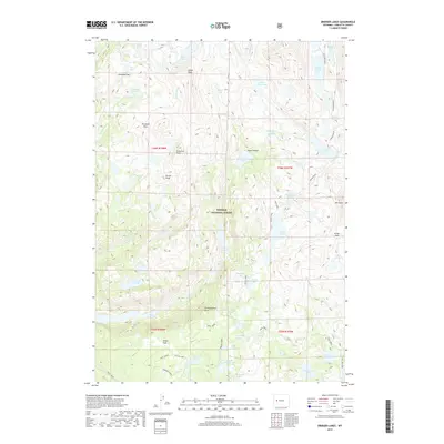
2017 Map of Bridger Lakes
USGS Topo · Published 2017About this map
Bridger National Forest defines this high-altitude landscape in Sublette County, where glacial basins and jagged peaks form a complex network of alpine drainage. The map provides a detailed view of the Wind River Range's hydrological systems, centered around the Titcomb Basin and a series of interconnected water bodies such as Seneca Lake, Island Lake, and the Titcomb Lakes. Significant elevation changes are marked by prominent summits like Elbow Peak and Guiterrez Peak, while transit across the Divide is traced through Gunsight Pass, Threlkeld Pass, and Lester Pass. This 2017 survey serves as a precise guide for those studying the topography of the High Divide, locating remote landmarks like Photographers Point and the dramatic Big Water Slide. The absence of permanent roads highlights the wilderness character of the region, where only footpaths like the Highline and Indian Basin trails provide access to the high lakes.
Find a feature on this map
60 named features on this map. Tap any name to fly to it.
Don’t see what you’re looking for? This feature index may not catch every label — zoom into the map to look around manually.
Map Details
Editions of this 2017 Bridger Lakes Map
This is the sole edition of this map. No revisions or reprints were ever made.
Other maps of this area

1909 · Fremont Peak
USGS Topo · 1:125,000

1955 · Thermopolis
USGS Topo · 1:250,000

1955 · Lander
USGS Topo · 1:250,000

1958 · Lander
USGS Topo · 1:250,000

1958 · Thermopolis
USGS Topo · 1:250,000

1961 · Lander
USGS Topo · 1:250,000

1962 · Thermopolis
USGS Topo · 1:250,000

1964 · Fremont Lake South
USGS Topo · 1:24,000
1968 · Fayette Lake
USGS Topo · 1:24,000

1968 · Fremont Peak North
USGS Topo · 1:24,000