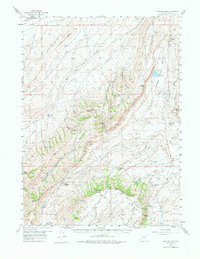
1956 Map of Bridger Pass
USGS Topo · Published 1976About this map
The Continental Divide carves a path through the center of this 1950s landscape, marking the high-altitude crest between the Sierra Madre and the high desert plateaus. The map details a rugged transition zone where industrial extraction and ranching life intersect. In the northeast, the Hatfield Oil Field and the Union Pacific railroad line signify the region's economic drivers, while the Overland Trail and Bridger Pass Road trace the historic routes of westward expansion. Several remote outposts, including Daley Ranch, McCarthy Ranch, and Lambertset Ranch, anchor the drainage basins of Separation Creek and Muddy Creek. These family-named landmarks, along with the distinct geological forms of Hogback Ridge and Red Rim, provide a clear picture of the remote homesteading and resource-based economy in Carbon County during the mid-twentieth century.
Find a feature on this map
53 named features on this map. Tap any name to fly to it.
Don’t see what you’re looking for? This feature index may not catch every label — zoom into the map to look around manually.
Map Details
Editions of this 1956 Bridger Pass Map
2 editions found
Other maps of this area

1932 · Savery
USGS Topo · 1:96,000

1940 · Savery
USGS Topo · 1:125,000

1953 · Rawlins
USGS Topo · 1:24,000

1954 · Rawlins
USGS Topo · 1:250,000

1956 · Rawlins Peak
USGS Topo · 1:62,500

1956 · Bridger Pass
USGS Topo · 1:62,500

1956 · Bolten Ranch
USGS Topo · 1:62,500

1957 · Doty Mountain
USGS Topo · 1:62,500

1958 · Rawlins
USGS Topo · 1:250,000

1961 · Middlewood Hill
USGS Topo · 1:24,000