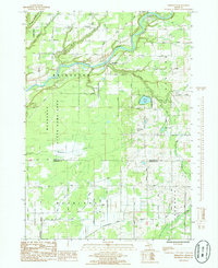
1985 Map of Bridgeton
USGS Topo · Published 1985About this map
The Muskegon River meanders through the heart of this landscape, anchoring the village of Bridgeton and defining the local topography as it flows toward the west. This 1980s-era survey highlights the transition between the managed wetlands of the Muskegon State Game Area and the agricultural plats of Moorland and Casnovia to the south. The rural character is punctuated by social and infrastructure markers like Bridgeton Ch and a central Cem, alongside specialized sites like the Stream Landing Strip and the Radio Tower (WZZM). In the southeastern corner, the small settlement of Trent sits near the headwaters of Crockery Creek. The map also captures the extensive footprint of the Muskegon County Wastewater Management System, a massive engineering project that significantly altered the drainage patterns and land use of the southwestern quadrant.
Find a feature on this map
45 named features on this map. Tap any name to fly to it.
Don’t see what you’re looking for? This feature index may not catch every label — zoom into the map to look around manually.
Map Details
Editions of this 1985 Bridgeton Map
This is the sole edition of this map. No revisions or reprints were ever made.
Other maps of this area

1930 · Muskegon
USGS Topo · 1:62,500

1936 · Muskegon
USGS Topo · 1:62,500

1945 · Ravenna
USGS Topo · 1:62,500

1954 · Milwaukee
USGS Topo · 1:250,000

1954 · Midland
USGS Topo · 1:250,000

1958 · Midland
USGS Topo · 1:250,000

1958 · Milwaukee
USGS Topo · 1:250,000

1958 · Twin Lake
USGS Topo · 1:62,500

1958 · Fremont
USGS Topo · 1:62,500

1959 · Midland
USGS Topo · 1:250,000