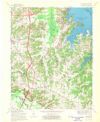
1969 Map of Briensburg
USGS Topo · Published 1970About this map
Kentucky Lake dominates the eastern landscape of this Marshall County survey, where the Tennessee River met the newly formed shoreline of the mid-twentieth century. The inland areas show a transition from traditional rural settlements like Briensburg and Palma to modern regional hubs such as Draffenville, situated at the intersection of major highway corridors. A mix of recreation and local industry is evident, from the Kentucky Dam Village State Park and an Amusement Park in the north to the numerous Gravel Pits in the southeast. Genealogists will find a dense concentration of family and community burial grounds, including the North Marshall Cem, Wilson Cem, and the Marshall County Memory Gardens. The map also captures specialized land uses such as the U S Reservation and the North Marshall High Sch, reflecting the community infrastructure supporting the post-war growth of the region.
Find a feature on this map
50 named features on this map. Tap any name to fly to it.
Don’t see what you’re looking for? This feature index may not catch every label — zoom into the map to look around manually.
Map Details
Editions of this 1969 Briensburg Map
This is the sole edition of this map. No revisions or reprints were ever made.
Other maps of this area

1928 · Eddyville
USGS Topo · 1:48,000

1929 · Smithland
USGS Topo · 1:62,500

1931 · Eddyville
USGS Topo · 1:62,500

1936 · Oak Level
USGS Topo · 1:24,000

1936 · Elva
USGS Topo · 1:24,000

1936 · Eddyville
USGS Topo · 1:48,000

1936 · Grand Rivers
USGS Topo · 1:24,000

1936 · Hardin
USGS Topo · 1:24,000

1936 · Smithland
USGS Topo · 1:48,000

1936 · Hiatt
USGS Topo · 1:24,000