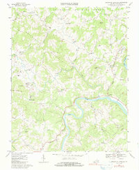
1967 Map of Brierpatch Mountain
USGS Topo · Published 1991About this map
Brierpatch Mountain dominates the landscape of this portion of Grayson County, where the highlands of the Jefferson National Forest meet the winding course of the New River. The map reveals a rural economy centered on local crossroads and natural resources, evidenced by the scattered locations of Clito Mill, Hacklers Store, and several gravel pits. Settlement patterns are defined by small communities such as Fallville and Spring Valley, which are anchored by a dense network of country churches including Jerusalem Ch, Ebenezer Ch, and Atkins Ch. The topography is marked by prominent peaks like Point Lookout Mtn and Lundy Knob, while the valley floors support local institutions like the Providence Sch and even a Drive-in Theater near Providence.
Find a feature on this map
51 named features on this map. Tap any name to fly to it.
Don’t see what you’re looking for? This feature index may not catch every label — zoom into the map to look around manually.
Map Details
Editions of this 1967 Brierpatch Mountain Map
Other maps of this area

1889 · Hillsville
USGS Topo · 1:125,000

1889 · Wytheville
USGS Topo · 1:125,000

1892 · Hillsville
USGS Topo · 1:125,000

1892 · Wytheville
USGS Topo · 1:125,000

1896 · Hillsville
USGS Topo · 1:125,000

1930 · Speedwell
USGS Topo · 1:62,500

1930 · Independence
USGS Topo · 1:48,000

1930 · Max Meadows
USGS Topo · 1:62,500

1931 · Galax
USGS Topo · 1:48,000

1933 · Independence
USGS Topo · 1:62,500