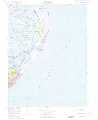
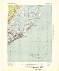
1952 Map of Brigantine Inlet
USGS Topo · Published 1973About this map
Brigantine National Wildlife Refuge dominates this coastal landscape, protecting a labyrinth of salt marshes and tidal channels such as Great Thorofare and Mile Thorofare. The map details the complex geography of Galloway before modern development reached its northern reaches, showing isolated landmasses like Egg Island and Salt Island amidst the shifting waters of Great Bay. Along the southern coast, the city of Brigantine shows significant growth by the early 1970s, with its streets and piers stretching toward Steelman Bay and Widgeon Bay. The intricate network of the Intracoastal Waterway and its Alt Route navigate through the Brigantine Channel, while historical structures like the Ruins near Little Beach and various Piers reflect the area's long relationship with the sea and the sand.
Find a feature on this map
47 named features on this map. Tap any name to fly to it.
Don’t see what you’re looking for? This feature index may not catch every label — zoom into the map to look around manually.
Map Details
Editions of this 1952 Brigantine Inlet Map
4 editions found
Other maps of this area

1887 · Atlantic City
USGS Topo · 1:62,500

1888 · Little Egg Harbor
USGS Topo · 1:62,500

1888 · Long Beach
USGS Topo · 1:62,500

1893 · Little Egg Harbor
USGS Topo · 1:62,500

1893 · Long Beach
USGS Topo · 1:62,500

1894 · Atlantic City
USGS Topo · 1:62,500

1919 · Long Beach
USGS Topo · 1:62,500

1920 · Little Egg Harbor
USGS Topo · 1:62,500

1940 · Atlantic City
USGS Topo · 1:62,500
1941 · Atlantic City
USGS Topo · 1:62,500
Featured Places
- Galloway Township, NJ
- Little Egg Harbor Township, NJ
- Brigantine, NJ
- Ocean County, NJ
- Atlantic County, NJ