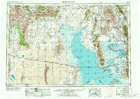
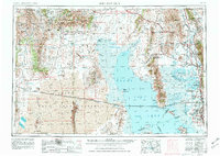
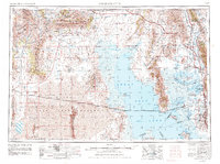
1954 Map of Brigham City
USGS Topo · Published 1972About this map
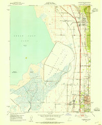
The Golden Spike National Historic Site anchors this look at northern Utah and southern Idaho, marking the historic meeting of the rails at Promontory Summit. The map illustrates a complex landscape of mid-century infrastructure and desert geography, dominated by the northern reaches of the Great Salt Lake and its numerous islands, including Dolphin Island and Gunnison Island. The transportation network is remarkably detailed, tracing the Lucin Cutoff across the water and the routes of the Southern Pacific and Union Pacific railroads through the high desert and mountain passes.
Find a feature on this map
135 named features on this map. Tap any name to fly to it.
Don’t see what you’re looking for? This feature index may not catch every label — zoom into the map to look around manually.
Map Details
Editions of this 1954 Brigham City Map
4 editions found

Other maps of this area

1885 · Salt Lake
USGS Topo · 1:250,000

1885 · Tooele Valley
USGS Topo · 1:250,000

1914 · Logan
USGS Topo · 1:125,000

1915 · Preston
USGS Topo · 1:96,000

1916 · Logan
USGS Topo · 1:125,000

1918 · Preston
USGS Topo · 1:125,000

1925 · Ft. Douglas
USGS Topo · 1:125,000

1928 · Ft. Douglas
USGS Topo · 1:125,000
1952 · Saltair NE
USGS Topo · 1:24,000
1952 · Farmington
USGS Topo · 1:24,000