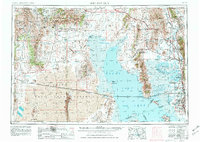
1954 Map of Brigham City
USGS Topo · Published 1981About this map
The Great Salt Lake dominates this mid-century landscape, revealing the complex relationship between the high desert and the industrial corridors of northern Utah. This survey documents the extensive rail infrastructure that defined the region, including the Southern Pacific tracks crossing the salt flats and the Golden Spike National Historic Site commemorating the meeting of the rails. The eastern margin shows the concentrated agricultural and urban growth in the Bear River valley, where settlements like Brigham City and Tremonton thrived alongside the Union Pacific lines. In contrast, the western reaches remain sparsely populated, anchored by remote points like Lucin and Kelton. The map also captures critical conservation and water management areas, from the Bear River National Wildlife Refuge to the Willard Reservoir, during a period of significant regional water infrastructure development.
Find a feature on this map
82 named features on this map. Tap any name to fly to it.
Don’t see what you’re looking for? This feature index may not catch every label — zoom into the map to look around manually.
Map Details
Editions of this 1954 Brigham City Map
4 editions found

Other maps of this area

1885 · Salt Lake
USGS Topo · 1:250,000

1885 · Tooele Valley
USGS Topo · 1:250,000

1914 · Logan
USGS Topo · 1:125,000

1915 · Preston
USGS Topo · 1:96,000

1916 · Logan
USGS Topo · 1:125,000

1918 · Preston
USGS Topo · 1:125,000

1925 · Ft. Douglas
USGS Topo · 1:125,000

1928 · Ft. Douglas
USGS Topo · 1:125,000

1952 · Saltair NE
USGS Topo · 1:24,000

1952 · Farmington
USGS Topo · 1:24,000