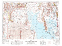
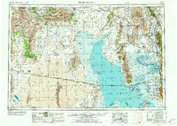
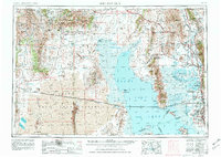
1954 Map of Brigham City
USGS Topo · Published 1985About this map
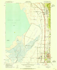
Brigham City and the surrounding agricultural and industrial corridor along the Bear River anchor this mid-century portrait of northern Utah. The map captures the vital transportation and conservation networks that define the region, from the northern reach of the Great Salt Lake to the slopes of the Raft River Mountains and Goose Creek Mountains. Notable for its historical significance, the Golden Spike National Historic Site is located near the Blue Creek Valley, marking the completion of the first transcontinental railroad. The industrial landscape is further shaped by the Southern Pacific and Union Pacific railroads, including the celebrated Lucin Cutoff which traverses the Great Salt Lake Desert.
Find a feature on this map
73 named features on this map. Tap any name to fly to it.
Don’t see what you’re looking for? This feature index may not catch every label — zoom into the map to look around manually.
Map Details
Editions of this 1954 Brigham City Map
4 editions found

Other maps of this area

1885 · Salt Lake
USGS Topo · 1:250,000

1885 · Tooele Valley
USGS Topo · 1:250,000

1914 · Logan
USGS Topo · 1:125,000

1915 · Preston
USGS Topo · 1:96,000

1916 · Logan
USGS Topo · 1:125,000

1918 · Preston
USGS Topo · 1:125,000

1925 · Ft. Douglas
USGS Topo · 1:125,000

1928 · Ft. Douglas
USGS Topo · 1:125,000
1952 · Saltair NE
USGS Topo · 1:24,000
1952 · Farmington
USGS Topo · 1:24,000