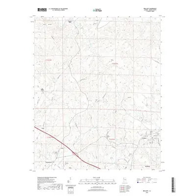
2018 Map of Brilliant
USGS Topo · Published 2018About this map
Pearces Mills sits at the northern edge of this Marion County landscape, where the Buttahatchee River meets Pearces Mill Cr. The area is defined by its numerous family and community burial grounds, such as Mount Pleasant Cem and Mays Cem, which reflect the long-standing genealogical roots of this part of Alabama. To the south, the settlement of Brilliant is established near Brilliant Lake, while Yampertown and Twin mark the path of the southern road corridor.
Find a feature on this map
71 named features on this map. Tap any name to fly to it.
Don’t see what you’re looking for? This feature index may not catch every label — zoom into the map to look around manually.
Map Details
Editions of this 2018 Brilliant Map
This is the sole edition of this map. No revisions or reprints were ever made.
Other maps of this area

1936 · South Of Hackleburg
USGS Topo · 1:24,000

1936 · Goddard
USGS Topo · 1:24,000

1953 · Birmingham
USGS Topo · 1:250,000

1956 · Birmingham
USGS Topo · 1:250,000

1956 · Gadsden
USGS Topo · 1:250,000

1957 · Birmingham
USGS Topo · 1:250,000

1958 · Gadsden
USGS Topo · 1:250,000
1958 · Haleyville West
USGS Topo · 1:24,000

1958 · Gold Mine
USGS Topo · 1:24,000

1960 · Gadsden
USGS Topo · 1:250,000