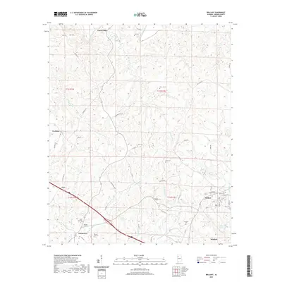
2020 Map of Brilliant
USGS Topo · Published 2020About this map
Pearces Mills sits at the northern edge of this Marion County landscape, where the Buttahatchee River winds through the hills of northern Alabama. The area's settlement history is marked by a dense concentration of family and community burial grounds, including the May and Akers Cem and Mount Pleasant Cem, reflecting the deep-rooted genealogies of this coal-rich region. In the southeast, the town of Brilliant is defined by its proximity to Brilliant Lake and its industrial heritage, while smaller communities like Twin and Yampertown are connected by a network of rural roads such as Scuffle Grit Rd and Center Church Rd. The terrain is characterized by the headwaters of Luxapallila Cr and prominent high points like Bee Mtn, illustrating the relationship between the upland topography and the creek valleys that shaped the development of these small mining and timbering towns.
Find a feature on this map
66 named features on this map. Tap any name to fly to it.
Don’t see what you’re looking for? This feature index may not catch every label — zoom into the map to look around manually.
Map Details
Editions of this 2020 Brilliant Map
This is the sole edition of this map. No revisions or reprints were ever made.
Other maps of this area

1936 · South Of Hackleburg
USGS Topo · 1:24,000

1936 · Goddard
USGS Topo · 1:24,000

1953 · Birmingham
USGS Topo · 1:250,000

1956 · Birmingham
USGS Topo · 1:250,000

1956 · Gadsden
USGS Topo · 1:250,000

1957 · Birmingham
USGS Topo · 1:250,000

1958 · Gadsden
USGS Topo · 1:250,000
1958 · Haleyville West
USGS Topo · 1:24,000

1958 · Gold Mine
USGS Topo · 1:24,000

1960 · Gadsden
USGS Topo · 1:250,000