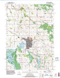
1992 Map of Brillion
USGS Topo · Published 1996About this map
Brillion serves as the central hub of this 1990s landscape, situated at the intersection of several rural township boundaries including Holland, Maple Grove, and Rantoul. The city's industrial footprint is clearly visible through the Industrial Waste Ponds and a network of arterial roads like Park Ave. Surrounding the urban center, the terrain is defined by the expansive Brillion State Wildlife Area, where Spring Creek and Black Creek meander through low-lying marshlands. This map reveals a high density of rural burial grounds, including the Evergreen Cemetery and Bluff Cemetery, which provide significant genealogical data points for local families. To the south, a chain of glacial lakes such as Long Lake, Becker Lake, and Grass Lake marks the transition into more varied elevations, punctuated by several Gravel Pits and a Quarry that hint at the region's active surface mining.
Find a feature on this map
67 named features on this map. Tap any name to fly to it.
Don’t see what you’re looking for? This feature index may not catch every label — zoom into the map to look around manually.
Map Details
Editions of this 1992 Brillion Map
This is the sole edition of this map. No revisions or reprints were ever made.
Other maps of this area

1954 · De Pere
USGS Topo · 1:62,500

1954 · Denmark
USGS Topo · 1:62,500

1954 · Chilton
USGS Topo · 1:62,500

1954 · Reedsville
USGS Topo · 1:62,500

1954 · Manitowoc
USGS Topo · 1:250,000

1955 · Green Bay
USGS Topo · 1:250,000

1958 · Manitowoc
USGS Topo · 1:250,000

1974 · Hilbert
USGS Topo · 1:24,000

1974 · Brillion
USGS Topo · 1:24,000
1974 · Chilton
USGS Topo · 1:24,000