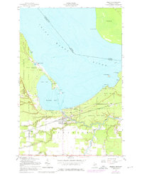
1951 Map of Brimley
USGS Topo · Published 1977About this map
Waiska Bay and the mouth of the Waiska River anchor this mid-century survey along the international border of the Saint Marys River. The settlement of Brimley serves as a local hub, where the Duluth South Shore and Atlantic railroad cuts through the landscape. This era shows the community supporting Superior High School and a Campground within Brimley State Park.
Find a feature on this map
40 named features on this map. Tap any name to fly to it.
Don’t see what you’re looking for? This feature index may not catch every label — zoom into the map to look around manually.
Map Details
Editions of this 1951 Brimley Map
2 editions found

Other maps of this area

1913 · Sault Sainte Marie
USGS Topo · 1:62,500

1941 · Sault Sainte Marie
USGS Topo · 1:63,360

1941 · Brimley
USGS Topo · 1:63,360

1951 · Shallows
USGS Topo · 1:24,000

1951 · Dollar Settlement
USGS Topo · 1:24,000

1951 · Raco
USGS Topo · 1:24,000

1951 · Kinross
USGS Topo · 1:24,000

1951 · Dafter
USGS Topo · 1:24,000

1951 · Brimley
USGS Topo · 1:62,500

1951 · Sault Ste. Marie
USGS Topo · 1:62,500