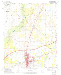
1971 Map of Brinkley
USGS Topo · Published 1973About this map
Brinkley serves as a critical junction in eastern Arkansas during the early 1970s, where the St Louis Southwestern and Chicago Rock Island and Pacific railroads intersect. This transportation hub is defined by a dense network of civic and community landmarks, including the Mercy Hospital, Federer Memorial Airport, and several schools like the Partee Sch and Vocational Sch. The surrounding landscape is characterized by the low-lying wetlands of the Mississippi Alluvial Plain, marked by the winding path of Bayou De View and Coon Tail Creek.
Find a feature on this map
48 named features on this map. Tap any name to fly to it.
Don’t see what you’re looking for? This feature index may not catch every label — zoom into the map to look around manually.
Map Details
Editions of this 1971 Brinkley Map
This is the sole edition of this map. No revisions or reprints were ever made.
Other maps of this area

1935 · Gregory
USGS Topo · 1:62,500

1939 · Hunter
USGS Topo · 1:62,500

1940 · Brinkley
USGS Topo · 1:62,500

1941 · De Valls Bluff
USGS Topo · 1:62,500

1948 · Helena
USGS Topo · 1:250,000

1950 · Helena
USGS Topo · 1:250,000

1953 · Memphis
USGS Topo · 1:250,000

1955 · Helena
USGS Topo · 1:250,000

1956 · Memphis
USGS Topo · 1:250,000

1956 · Hunter
USGS Topo · 1:62,500