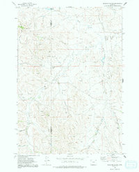
1972 Map of Brislawn School
USGS Topo · Published 1991About this map
Brislawn Sch stands in the southeastern portion of this map, serving as a focal point for the rural community on the high plains of northeastern Wyoming. The landscape is defined by an intricate drainage system including Horse Creek, Prairie Creek, and Short Prong Prairie Creek, which carve through the open terrain along the border of Campbell and Crook counties. The topography is characterized by a series of draws and hollows such as Heald Draw, Anderson Draw, and Dry Hollow, reflecting the region's semi-arid character and reliance on water features like Edgerton Reservoir. Evidence of human activity is found in the Gravel Pit and the long Pipeline corridors that traverse the prairie. This 1970s survey illustrates a specialized ranching and energy landscape, where the vastness of the Duck Creek Breaks is punctuated by these vital water sources and remote educational outposts.
Find a feature on this map
17 named features on this map. Tap any name to fly to it.
Don’t see what you’re looking for? This feature index may not catch every label — zoom into the map to look around manually.
Map Details
Editions of this 1972 Brislawn School Map
2 editions found
Other maps of this area

1905 · Devils Tower
USGS Topo · 1:125,000

1954 · Gillette
USGS Topo · 1:250,000

1955 · Gillette
USGS Topo · 1:250,000

1957 · Oshoto
USGS Topo · 1:62,500

1957 · Cedar Ridge
USGS Topo · 1:62,500

1958 · Gillette
USGS Topo · 1:250,000

1962 · Gillette
USGS Topo · 1:250,000
1972 · Bonnie Reservoir
USGS Topo · 1:24,000
1972 · Bowman Hill
USGS Topo · 1:24,000
1972 · Brislawn School
USGS Topo · 1:24,000