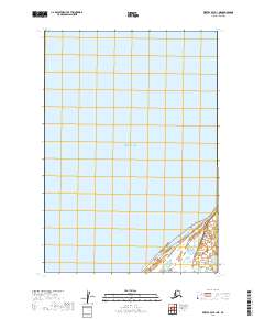
2019 Map of Bristol Bay B-1 NE
USGS Topo · Published 2019About this map
Bristol Bay dominates the vast majority of this survey, which primarily documents the marine environment and coastal interface of southwestern Alaska. The map traces the transition from the open waters of the bay to the shoreline, marked by shifting sand and intricate wetland systems. As an official U.S. Geological Survey product, it meticulously grids the maritime area according to the Public Land Survey System, specifically defining the boundaries for T31s R54w and T32s R54w. The inclusion of bathymetric or coastal contour data reveals the subtle topography of the seabed and intertidal zones, reflecting the dynamic nature of this remote coastline where tidal flats and shallow waters are the primary geographical features.
Find a feature on this map
3 named features on this map. Tap any name to fly to it.
Don’t see what you’re looking for? This feature index may not catch every label — zoom into the map to look around manually.
Map Details
Editions of this 2019 Bristol Bay B-1 NE Map
This is the sole edition of this map. No revisions or reprints were ever made.
Other maps of this area

1943 · Ugashik
USGS Topo · 1:250,000

1948 · Ugashik
USGS Topo · 1:250,000

1949 · Ugashik
USGS Topo · 1:250,000

1951 · Bristol Bay
USGS Topo · 1:250,000

1951 · Ugashik C-6
USGS Topo · 1:63,360

1963 · Ugashik B-6
USGS Topo · 1:63,360

1963 · Bristol Bay
USGS Topo · 1:250,000
1963 · Bristol Bay B-1
USGS Topo · 1:63,360

1963 · Ugashik
USGS Topo · 1:250,000
1967 · Bristol Bay
USGS Topo · 1:250,000