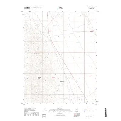
2018 Map of Bristol Range SE
USGS Topo · Published 2018About this map
The Bristol Range dominates the western half of this Lincoln County landscape, rising to its highest elevation at Roe Peak. This 2018 survey illustrates the sharp transition between the steep, corrugated terrain of the range and the high desert flats of Lake Valley to the east. Along this geological boundary, the drainage patterns are clearly defined by the deep incisions of Burnt Canyon and Broad Canyon, which funnel seasonal runoff toward the basin floor. Human modification of this arid environment is evident in the presence of the Rockhouse Reservoir, situated near Page Cr in the northeast. Farther south, the isolated prominence of Blind Mtn stands apart from the main range, overlooking the expansive valley. The map provides a detailed view of these natural landmarks and the primitive road networks that navigate the desert floor and mountain foothills.
Find a feature on this map
12 named features on this map. Tap any name to fly to it.
Don’t see what you’re looking for? This feature index may not catch every label — zoom into the map to look around manually.
Map Details
Editions of this 2018 Bristol Range SE Map
This is the sole edition of this map. No revisions or reprints were ever made.
Other maps of this area

1885 · Pioche
USGS Topo · 1:250,000

1886 · Pioche
USGS Topo · 1:250,000

1915 · Bristol Range
USGS Topo · 1:62,500

1916 · Highland
USGS Topo · 1:62,500

1917 · Bristol Range
USGS Topo · 1:62,500

1918 · Highland
USGS Topo · 1:62,500

1921 · NW 1/4 Panaca
USGS Topo · 1:48,000

1953 · Highland Peak
USGS Topo · 1:24,000

1953 · Bristol Range SE
USGS Topo · 1:24,000

1953 · Pioche
USGS Topo · 1:24,000