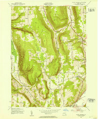
1943 Map of Bristol Springs
USGS Topo · Published 1953About this map
Gannett Hill and the dramatic drop known as The Jumpoff overlook the glacial valleys of Ontario County in the early 1940s. This survey records a landscape of steep ravines and ridges where rural life was organized around small district schools, such as School No 8 and School No 2. Settlement is clustered in hamlets like South Bristol and Bristol Springs, or at road junctions like Boswell Corners. In the southern portion of the quadrangle, the Lehigh Valley railroad cuts through the valley floor near Naples, supporting the local economy. Genealogists can locate family sites through features like Parmeley Cem and Hunt Hollow Cem, while the presence of Gas Wells near the valley floor indicates the era's emerging natural resource extraction alongside traditional farming.
Find a feature on this map
36 named features on this map. Tap any name to fly to it.
Don’t see what you’re looking for? This feature index may not catch every label — zoom into the map to look around manually.
Map Details
Editions of this 1943 Bristol Springs Map
4 editions found
Other maps of this area

1900 · Naples
USGS Topo · 1:62,500

1900 · Canandaigua
USGS Topo · 1:62,500

1901 · Honeoye
USGS Topo · 1:62,500

1902 · Wayland
USGS Topo · 1:62,500

1903 · Naples
USGS Topo · 1:62,500

1903 · Canandaigua
USGS Topo · 1:62,500

1904 · Wayland
USGS Topo · 1:62,500

1904 · Honeoye
USGS Topo · 1:62,500

1913 · Naples
USGS Topo · 1:62,500

1942 · Springwater
USGS Topo · 1:31,680