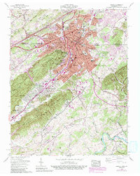
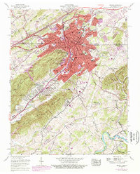
1959 Map of Bristol
USGS Topo · Published 1992About this map
The bi-state city of Bristol sits split between Tennessee and Virginia in this 1959 survey, showing a significant regional hub defined by education and transportation. The map captures the city's academic core, featuring institutions like Sullins College, Virginia Intermont College, and King College. Transport and commerce are anchored by the Union Depot, where the Southern Railway and Norfolk And Western Railway converge, and the historic Daniel Boone Trail following the valley floor. Beyond the urban grid, the landscape transitions into the distinctive geology of The Knobs and the Paperville Knobs. To the south, the Bristol International Speedway is visible near Vance, while the South Fork Holston River winds through the southeastern corner within the Cherokee National Forest. This document provides a detailed record of the mid-century expansion into neighborhoods like Fairmount and Virginia Heights before later suburban shifts.
Find a feature on this map
106 named features on this map. Tap any name to fly to it.
Don’t see what you’re looking for? This feature index may not catch every label — zoom into the map to look around manually.
Map Details
Editions of this 1959 Bristol Map
5 editions found
Other maps of this area

1891 · Roan Mountain
USGS Topo · 1:125,000

1894 · Roan Mountain
USGS Topo · 1:125,000

1897 · Bristol
USGS Topo · 1:125,000

1902 · Bristol
USGS Topo · 1:125,000

1904 · Roan Mountain
USGS Topo · 1:125,000

1934 · Wallace
USGS Topo · 1:24,000

1934 · Holston Valley
USGS Topo · 1:24,000

1934 · Wyndale
USGS Topo · 1:24,000

1934 · Bristol
USGS Topo · 1:24,000

1935 · Watauga Valley
USGS Topo · 1:48,000